About Me

Hamilton, Waikato, New Zealand
In 2012 I decided to challenge myself. I plan to climb as many mountain peaks in the North Island this year as I can. This is known as "peak bagging", the original idea coming from the highlands of Scotland. Come with me on this adventure as I travel around NZ's north island collecting all the mountains she has to offer, and hopefully some fantastic views too!!

Monday, 20 January 2014

Mt Ngauruhoe (2,291m) / Mt Tongariro (1,967m)


Well after several months of no climbing it was time to make up for it with two of the biggest combined into one trip.  My climbing partner on this trip was my good friend Kerryn Reardon.  We set off for national park for an overnight stay to ensure a very early start in the morning in order to complete these two peaks in the one day.
Mt Ngauruhoe
Mt Tongariro

We parked in the carpark at the Mangetepopo end of the Tongariro crossing track and headed towards the hut, about 20 min in.  At this stage the cloud was low but we were optimistic that it would lift later on, as I'm sure were the dozens of other people on the track.  After stoopping at the hut for a quick break we continued on the track, gradually getting higher and higher as we went. After a couple of hours we reached the turnoff and headed for the summit of Mt Ngauruhoe, whie most of the others carried on over the main route of the crossing.
Mt Ngauruhoe scree slope with Tongariro complex behind

This was a hard slog up a decent scree slope initially guided by poles.  Visability was still patchy so we climbed one pole at a time and reassessed.  Our climb continued, taking regular breaks to catch our breath and much on a snack.  Finally we broke out above the cloud to find a gorgeously clear blue sky and the sun shining.  A little further and a scramble up the lip of the crater, and passing some active steam vents, we found a spot on the crater edge for lunch.  Views of Mt Ruapehu peaked out from behind the crater rim and blue lake towards the far end of the crossing were visible between banks of cloud.

Mt Ruapehu peeking out from behind the crater rim of Mt Ngauruhoe

 After lunch and some photos we headed back oughly the same route we came up, only instead of the 3 1/2  hour slog to get to the top it was a very fast 3/4 hour scree slide down which was geat fun for the pair of us.  Back at the turnoff point we heaed right, back on the main crossing track and carried on our trek.  A brisk climb up red crater ensued, this is the highest point on the track and is where we decided to call it a day as the weather was rapidly closing in.  However not before taking in and getting some last minute photos of the expanse of the crater floor from the rim.  Finally as the wind really started to pick up we headed back down.

Retracing our steps all the way back down seemed to take forever but finally we rereached the hut for a well earned break.  From here it was a reltively short trip back to the car but it still felt like it would never end.

So, after ten hours fom start to finish we reached the car and headed home with the satisfaction of knowing we had bagged these two peaks in one hit.  For me this mission is almost complete with only a couple to go...heres to the next time...

Friday, 12 April 2013

Mt Ruapehu (2,672m)


Well, let me start by saying yes it has been a while since my last climb, needed to tak a break and enjoy my baby girl being born and settling into life as a new father.  So now it is time to get the last few climbs done...


Mt Ruapehu (2797m)

 Mt Ruapehu, the highest peak of my North Island collection was the pinnacle of this peakbagging mission and a completely enjoyable, but tough climb done with my wonderful father-in-law, Selwyn Warren, a fit young man of 70..  We did this one as a guided trip and met our guide at the carpark at the top of the Bruce Road off SH47, starting our ascent at about 1,600m above sea level.  From there we caught the ski lifts to begin climbing proper at 2000m.


View from ski lifts looking towards summit

Now the real work began.  We follwed the ski run for a while and then crossed westward and zigzaged our way up the flank of the mountain, stopping along the way for photo opportunities and well neeed rest stops.  Despite starting so high this was no easy trek!!  The weather was clear and great views of Mt Ngauruhoe, Mt Tongariro and out westward Mt Taranaki were nice to behold.  Eventually after a solid three hours of climbing we reached the start of a narrow ridge that leads to the highest point above the crater lake at 2,672m.  Although the true summit of Ruapehu stands at 2,797m this is the higest accessible point allowed to be reached, and is officially recognised as the peakbagging summit.


Mt Ngauruhoe seen from Ruapehu slopes

The crater lake was in a word...beautiful.  A wonderul turquoise blue with whispers of steam coming off it surrounded by snow and rock walls was just fantastic, and deceptively peaceful.  It looked very full despite the drought we are all in .We stayed long enough to get yet more fantastic photos and have a well earned lunch break before heading back down the mountain.

Mt Ruapehu crater lake and summit

Our trip down was a different trek altogether.  Follwing a much steeper route down the valley we made great time travelling down over jagged rock beds and snow strips (great fun!, including watching Selwym arse over several times on them!) and rejoined the ski run we had initially followed up.  Upon reaching the top of the ski lifts we stopped at the cafe' (the highest cafe' in the southern hemisphere) for a snack and water refill.  Then, jumped back onto the skilift for the relaxing ride back to the carpark, and of course taking more photos on the way down. 


Selwyn Warren negotiating  snow on our descent
In summary this was the highest peak "bagged" and well worth the effort.  Next will be the other two peaks in the Tongiriro national park...watch this space...

Tuesday, 6 November 2012

Otanewainuku (640m)

After the last couple of big peaks this one is small by comparison.  It is also the smallest peak in this collection but still worthy of bagging.

Otanewainuku is a volcanic rocky outcrop just inland from Tauranga in the Bay of Plenty.  The track begins at a carpark just off a dirt road that links Tauranga with Te Puke.  Done with my father-in-law we headed into the bush and followed the track which is relatively flat for a while but then steadily gets steeper and steeper until the summit is reched.  Here a wooden platform stands to allow views over the surrounding bush.

Views include the Kamai ranges, Mt Tarawera and Mt Edgecombe and of course Tauranga harbour. 

Despite being a short climb it is worth including it, a nice morning's bag...

Friday, 2 November 2012

Mangaweka (1,733m)

At 1,733m above sea level this is the highest peak of the Ruahine range situated nar Palmerston North.  Completed this one with my 15 year old nephew on a stunning spring day.


Mangaweka (1,733m)

The track begins inland from Mangaweka village or alternatively you can travel north from Kimbolton on some back roads which is what we did.  A carpark at the end of a long dirt road is where the track begins.  Initially crossing over farmland, a small steam and then following a fenceline up a very steep spur leads to the Ruahine park boundary.  Here you enter the bush and meander your way up towards Purity Hut which is situated just above the bushline.  We refilled our water bottles here and had a snack before heading up through the tussock towards the open tops of the range.  A series of ridgelines leads to a summit known as Wooden Peg where the track splits.  A little further on is Iron Peg and then a short side trip leads to the Mangaweka summit proper.

Looking toward Mangaweka summit from Iron Peg

View of Mt Ruahepu from Mangaweka
The views all the way up are spectacular with Mt Ruapehu, Mt Ngauruhoe, Mt Tongariro and even Mt Taranaki visible in the distance.  From the summit the full extent of the Ruahine range is seen with views in every direction.  It is also noteworthy that there are several sharp drop offs around too.  To cap it of there were large patches of snow still around despite it being now November.

Looking over ruahine ranges from Mangaweka summit


Our trip back down was fairly rapid and we rereached the hut in a very short time.  Tramping across open tops is so much easier than walking through bush, a fact our knees appreciated greatly.  Once back to the park boundary we picked up the fenceline again and very gingerly made our way down it.  A final push to the carpark ended this one in a little over seven hours, but worth every step.

Another peak successfully bagged...

Tuesday, 16 October 2012

Umukarikari Peak (1,591m)

Umukarikari is the highest accessible peak in the Kaimanawa ranges.  These form part of the central high country along with the Central Plateau volcanoes.  The start of this track is 4km off of State Highway 1 at the start of the desert road, 15 Km south of Turangi.

The track begins in dense bush and makes its way upward at a fairly steep and constant incline until you reach the bushline.  Almost instantly you lose the bush at this point and begin  walking across alpine herb fields that lead into tussock as you gain altitude.  Marker posts are posted regularly along the route which guide you along the rolling tops of the Umukarikari range, up over a peak simply known as Sharp Cone (1,480m) and then onward a little further to reach the summit of Umukarikari (1,591m).  It took three hours to reach the summit but well worth the slog. A decent stop here for lunch and to take some photos of course.

Mt Ruapehu and Ngauruhoe from Urukarikari range tops

Views are to be had most of the way above the bushline, including stunning views of Mt Ruapehu, Mt Ngauruhoe and Mt Tongariro. Lake Taupo, Mt Tuhara were also visible through the haze aswell as the rest of the Kaimanawa ranges to boot.

The trek back down was somewhat faster (2 hours) and after five hours of wallking and climbing I was happy to reach the carpark and head back home. A great days tramp and another peak successfully bagged.

Not many to go now...

Saturday, 15 September 2012

Mitre Peak (1571m)

Well, this peak is the highest point in the Tararua range and was a lesson in humility to say the least.  It certainly ranks as the hardest climb I have done,despite the fact it isn't the highest.  The track begins at a carpark area known as "The Pines" inland from Masterton.  Initially the track is a 4WD track that meanders slowly uphill to meet the bush.  This track follows the Waingawa river virtually all the way to the hut.  However the first three hours of this tramp are very up and down with several stream crossings to boot.  At some points you are very high above the river and realise how much altitude you have gained.  Unfortunately, to reach the hut the track drops back down to the river level where you cross a nice new foot bridge and beyond the hut the climb to Mitre begins all over again!

Mitre Flats Hut, at the base of Mitre peak, Tararua range

After a brief stop at the hut to eat and refill my water bottle I headed off.  The track initally heads up a very steep incline that has you gaining altitide at a rapid rate.  It then becomes a steady plod uphill with occasional steep sections.  The higher I got there was snow on the ground around  from the previous couple of days. After more climbing the views get better despite the mist and snow but at this point, approximately 3/4 up this one, (1200m approx)  a stones throw from the true summit, I made the call to turn back and head down as I was going to run out of visibility any higher and light on the trip down.  The trip down was somewhat faster but still required some agile foot placement and care.  After making my way back out from the hut I reached the carpark at the start of the track just on dusk, very timely!!

Looking back to Mitre peak, shame its clouded in!!

On the whole this cimb took everything I had but despite not quite reaching the absolute top, it was a hard slog climb that took 9 hours and certainly worthy of being called bagged.

The next one...watch this space...

Friday, 7 September 2012

Mt Ngongataha (756m)

Another relative smallish peak just to get back into the swing of things...

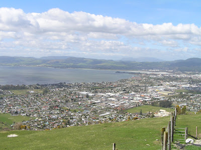
Rotorua city and the lake from Mt Ngongataha

Mt Ngongataha is situated on the outskirts of Rotorua.  The track to the summit begins at the carpark on Paradise Valley Road and climbs steadily through the bush to meet the access road near the top.  At the summit there unfortunately are no views to be had due to major shrubery growth , but views can be obtrained from a few hundred metres down the access road. From here the lake, Mt Tarawera and all of Rotorua city can be seen.

A good climb done within a couple of hours, good practise for the next one...